Massive and Repeated NOAA Exaggeration of Tropical Storm Strength
The Desperate, Frantic Search for Clicks and Views. Idalia is a Great Example. Nearly Every Storm is Exaggerated by a Huge Amount

“Hurricane” Idalia is being hyped to the moon as a MAJOR HURRICANE!! CATEGORY 3!! RUN FOR YOUR LIVES!!. THE STRONGEST HURRICANE EVER IN THE BIG BEND OF FLORIDA!!! The sad thing is that this type of exaggeration is routine now. The NOAA will give a name to a tropical low pressure area (depression) for God’s sake. They’ll call a tropical depression a tropical storm and they call a tropical storm a strong hurricane! They do it all the time. They are lying all the time!
They’re naming winter storms with names for God’s sake! It’s really a joke. They’re desperately begging for viewers!
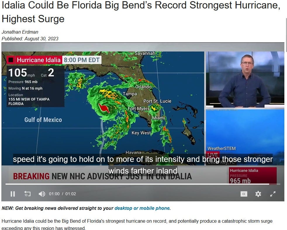
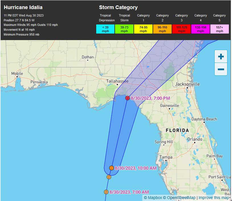
Here’s the computer model projection of the storm path and strength. The storm’s strength at landfall is HYPED at 111 to 129 miles per hour. Wow, Category Three!
The Problem?? Idalia will NOT EVEN BE A Hurricane at landfall. How do I know? One just has to look at the generated forecast for a town or community underneath the path of the storm’s eye.
In this case, Perry, Florida is just right of the storm’s forecasted eye, ie., the strongest quadrant of the storm is the northeast eyewall. (It’s an extremely unpopulated area of Florida and about 30 to 40 miles inland.) It’s forecasted to be a direct hit on Perry, FL.
Below, I show the computer model forecasted weather conditions for Perry, Florida (not subject to NOAA hype). It’s calling for SUSTAINED winds of 40 to 60 mph at Perry at a maximum. Many, many times, I’ve confirmed that it’s these forecasts that are quite accurate. I’ve looked many times at various continuously recording weather stations, preferably local airports, after storms pass. I’ve seen for myself that weather stations usually match these forecast model’s wind strengths. And I’m always looking for airport weather stations on the NE side of the eye for maximum wind strength. (Hey, I’m an engineer and science guy, what can I say?)
So, here’s the maximum storm strength expected at Perry (will likely be proven quite accurate):
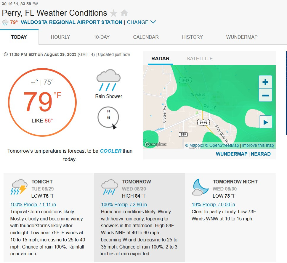
The maximum sustained winds expected in this sparsely populated area near Perry, Florida is forecasted at only 40 to 60 mph. (Sustained winds are wind speeds that are sustained for at least one minute duration—it’s NOT gusts, which can be higher). Yes, there will be higher gusts. If you watch the weather channel, they’ll be reporting only wind gusts which will STILL be guaranteed to be MUCH lower than Category 3 and probably not even be a Cat 1.
You’ll see! Or maybe you’ve already noticed this.
Category 3 winds are 111 to 129 mph or very devastating conditions. As a child living in South Florida, I remember a hurricane passing over our house one night. It was Hurricane Cleo in the early 1960s and it was a Category 3 storm. It was incredibly loud and damaging. I remember very clearly the loud moan of that type of wind. Our house was built with concrete hollow block construction and aluminum shutters covered all of the windows.
The eye of the storm passed over my house and I can remember my mom opening the door when the eye was overhead to see trees stripped of leaves and limbs and and other damage. You often can see clear skies in the eye of these storms and calm but hot and oppressive conditions. (I remember clutching my mom’s calf-length skirt which was the style in the early 60s) That storm tore all of our house’s roofing materials down to bare wood. Rainwater was dripping everywhere in the house and my mother put pots, pans and anything else available to catch the drips. We were without power for seven days.
Perry Florida will not even experience true hurricane force conditions. Yes, there may be gusts up to hurricane strength but that’s not the criteria. And yes, there may be imbedded tornados in these storms that may cause localised and severe wind damage. And if you’re on the coast, wave and water damage can be very bad, even for tropical storms. There's no denying that.
For Idalia, the storm surge, wind and rainfall will VERY LIKELY correspond to a strong tropical storm—NOT EVEN A HURRICANE. I can’t even begin to tell you how many times that I have verified this type of exaggeration; it’s routine. Hey, I’m a man of science— an engineer—who researches these kinds of things and verifies these things factually.
Nearly everything is a lie or exaggeration in our country. There is an extreme and fraudulent effort for every person or organization online to rack-up clicks and views. There is a real desperation: please look at me!! Just look at titles of YouTube videos! Clickbait is everywhere!! It’s the story of our time.
Because that area of Florida is so sparsely populated, and with no amateur or other weather stations that will have power and online, I won't be able to do a post-mortem check for this storm. So, I'll admit that this won't be the example that I was looking for.
My guess is that they will call this a Cat 5 and link it to global warming, etc. A Cat 5 would maintain the "inflation" margin of 3 categories (the storm is Cat 2). Like I said, I won't have any data to look at near landfall. In that regard, it'll be like hurricane Patricia that was sold as a Cat 5 and strongest storm EVER. It hit south of Puerto Vallarta. A few storm chasers were there and the storm lasted about 20 minutes---more like a wide tornado than a hurricane. No one at the NOAA will ever seek to re-characterize that storm as something other than a hurricane. Patricia totally dissappated shortly after landfall and no storm watchers could even find any damage--which is weird for "the most powerful hurricane IN HISTORY!!" Even satellite imagery shows that this "storm" dissappated instantly upon landfall. There wasn't even any rain reported in PV, Guadalajara or any city near landfall.
I see that Wunderground.com has raised max wind speeds in Perry to 80 to 100 mph. That's quite a big change. Their advertising Idalia as having strengthened to a Cat 4, but 80 to 100 mph is Cat 2-ish. So, this storm is outperforming my expectations. Cat 2 is pretty bad. I'm not going to lie. I'll update later